The Kumano Kodo trails meander through the remote mountains of the Kii Peninsula, located approximately 100 kilometers south of Osaka. Steeped in history, devout Buddhist pilgrims from all walks of life once used these ancient trails as a religious passage. Former emperors, aristocrats, women of royal status, and commoners all shared the paths that criss-cross the misty mountains. Today, walking the Kumano Kodo is an excellent way to experience one of Japan’s most spiritual countrysides and explore the beauty and nature of the landscape. Discover the magic of hiking the Kumano Kodo as we share the history of the pilgrimage, give you tips on how to make the most of your Kumano Kodo hike, and take you through the important Nakahechi trail to encounter the “Three Grand Shrines of Kumano”.
About the Kumano Kodo
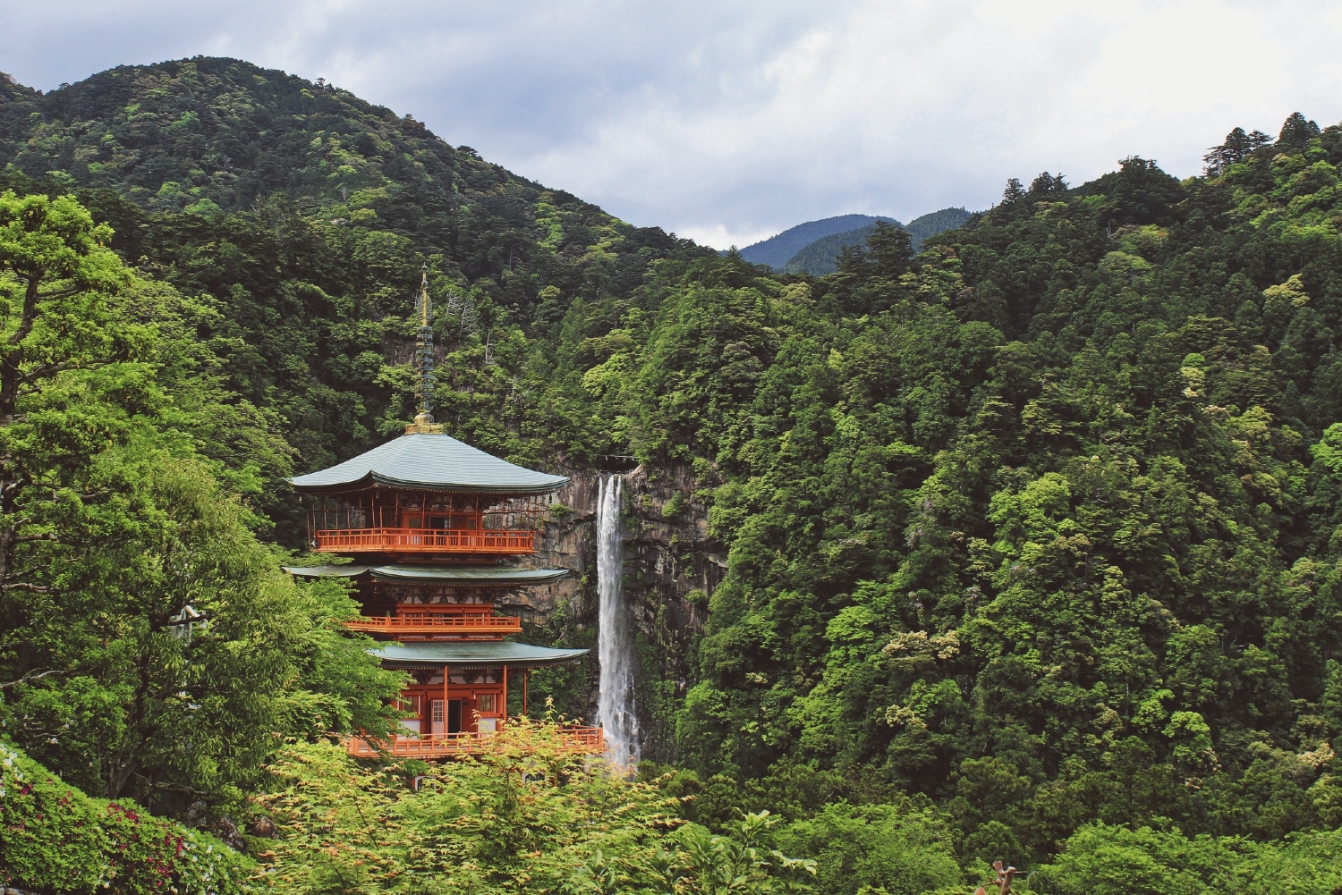
The Kumano Kodo goes by many names, including the “Kumano Old Road” and “Kumano Ancient Trail”. Spanning several prefectures, including Mie Prefecture, Nara Prefecture, Wakayama Prefecture, and Osaka Prefecture, the Kumano Kodo is actually a sprawling network of many ancient trails that cover the Kii Peninsula mountain range. Many of these trails converge on the grand Kumano Hongu Taisha, a sacred Shinto shrine in the heart of Wakayama Prefecture. It is the most significant of the three shrines that make up the Kumano Sanzan, or “Three Grand Shrines of Kumano”. The other two shrines are the Kumano Nachi Taisha, famous for its postcard-perfect waterfall and tower, and the Kumano Hayatama Taisha, both of which you’ll find near the eastern coast of Wakayama.
For over 1,000 years, the many trails of the ancient pilgrimage network served as an integral part of the pilgrimage process, as pilgrims undertook religious rites of purification and worship along the course of their journey. To this day, its importance is celebrated by many people in Japan and around the world, evident by the number of people who attempt the journey annually. In 2004, the Kumano Kodo became a UNESCO World Heritage Site.
The most popular of all the trails is the Nakahechi, also known as the “Imperial Route”. Pilgrims taking the Nakahechi will encounter all three of the sacred Kumano Sanzan. This route is also the most accessible route for hikers — it is well-signed, well-traveled, and passes through many hamlets that offer inns and homestays along the way to ensure a comfortable journey. We’ll be covering the Nakahechi trail in this guide.
Collecting stamps along the way
When undertaking this pilgrimage, you will come across stamp stations at the most popular sites of the Kumano Kodo. The stamps are a great way to mark your checkpoints, and the task delivers a fantastic feeling of accomplishment as you fill in your stamp booklet. By stopping at regular intervals, you become mindful of the path you tread, and you feel as though you are taking part in a once-in-a-lifetime scavenger hunt. Each station has its own distinct stamp, all of them intricate and special.
If you want to take your pilgrim journey to the next level, take up the challenge of completing the Dual Pilgrim Credential. The Dual Pilgrim Credential is a “passport” that proves you have walked the two UNESCO World Heritage pilgrimage routes: The Kumano Kodo and the Way of St. James (Camino de Santiago). You collect your stamps in this booklet as you traverse the many checkpoints. Completing both pilgrimage routes earns you a limited edition pin badge.
You can get the Dual Pilgrim Credential booklet free of charge at multiple sites in Japan, including the Tanabe Tourist Information Center, Kumano Hongu Heritage Center, and even at some accommodation lodges along the trail. Find out more about earning the Dual Pilgrim status here.
The Nakahechi trail
The Nakahechi is the core trail of the Kumano Kodo pilgrimage network, along which you will encounter the three famous Kumano shrines that make up the Kumano Sanzan: Kumano Hongu Taisha, Kumano Hayatama Taisha, and Kumano Nachi Taisha. The trail is well-maintained and clearly marked with signs in both English and Japanese. This trail also has the best infrastructure and safest paths of all the Kumano walks.
Accommodation
Traditional inns can be found at every stop along the way to provide hikers with communal hot baths, comfortable futons, and delicious local meals. While there are plenty of options for lodging in the region, it is best to book your accommodation in advance before setting off on your journey. The Tanabe City Kumano Tourism Bureau runs the Kumano Travel Reservation System, a website that lists accommodation providers across the entire trail network.
Distance
The Nakahechi spans the width of the peninsula from west to east and covers a distance of around 70 kilometers. There are sections where hikers may need to take a bus or a boat, meaning the walking distance will be different to the total distance. If you choose to visit all three of the Kumano Sanzan shrines and lodge at the various towns in between, the journey will typically take around 4 – 5 days.
Making your way through the Nakahechi trail
Here is our guide to the many stopovers along the Nakahechi as we journey from the starting point of Takijiri-oji in the west to the grand Kumano Nachi Taisha in the east.
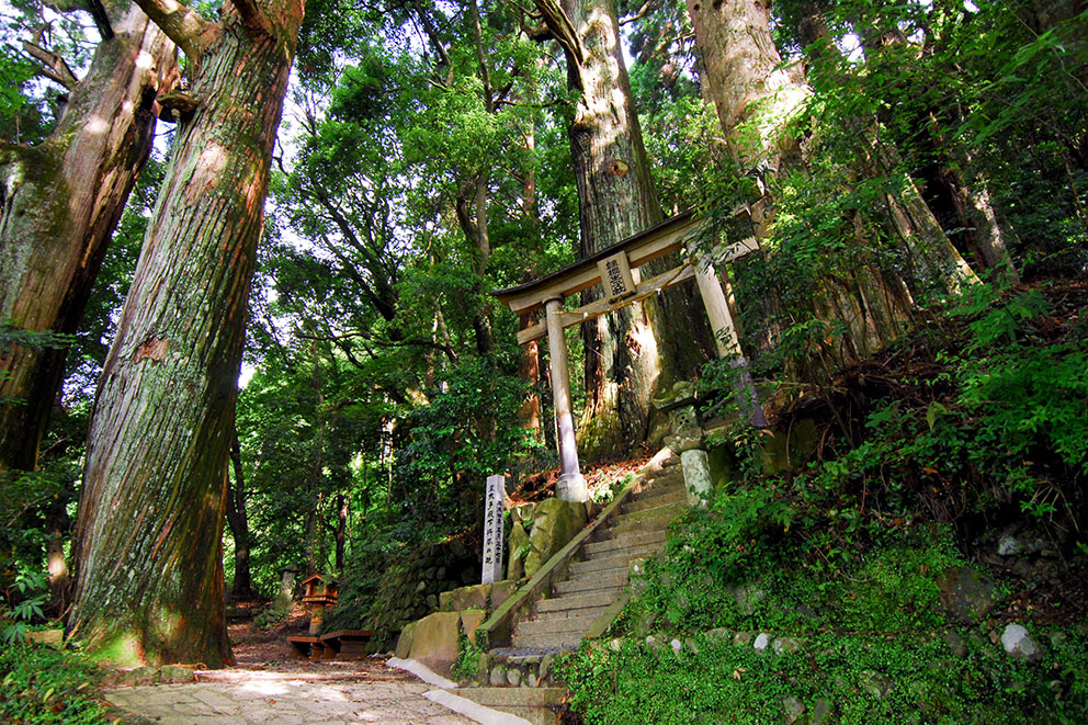
Takijiri-oji
Takijiri-oji is a picturesque Shinto shrine hidden amongst the old growth of a pine forest next to the Tonda River. It marks the spiritual entrance to the sacred Kumano mountains and is the most common starting point for travelers walking the Nakahechi trail. The trailhead starts just behind the historic shrine. Here, you’ll find a sign indicating the first leg of your journey: a 3.7-kilometer hike to Takahara. As you trek through the native forest, you will pass the turtle-shaped rock of Tainai Meguri and come to a lookout point that offers lovely views before reaching Takahara.
How to get to Takijiri-oji:
Kii-Tanabe, located on the west coast of Wakayama Prefecture, serves as the main gateway to the Kumano Kodo. The best way to get there is by the express train that runs between Shin-Osaka Station and Kii-Tanabe Station. The journey takes just over two hours. From Kii-Tanabe, take a local bus next to Tanabe station to Takijiri-oji, the Nakahechi trailhead.
Takahara
Distance from Takijiri-oji: 3.7 kilometers
Total elevation gain: 430 meters
Total elevation loss: 200 meters
The Takahara village is the first stop on the Nakahechi trail. Known locally as Kiri no Sato, or “Village in the Mist”, the area is incredibly scenic with its panorama of valleys and foggy mountains stretching far and wide. Here, you will find terraced rice fields, giant camphor trees, and the colorful Takahara Kumano-jinja.
Tsugizakura-oji
Distance from Takahara: 13 kilometers
Total elevation gain: 830 meters
Total elevation loss: 650 meters
As you continue east, the mountain trail passes through Chikatsuyu village and onwards toward Tsugizakura-oji. Some prefer to break this section into smaller walks. Along the way, you will pass rest areas and teahouses before coming to the mystical Tsugizakura-oji, an ancient shrine dedicated to the enormous cedar trees growing in the area. These centuries-old trees have branches that are said to grow in the direction of Nachi Falls!
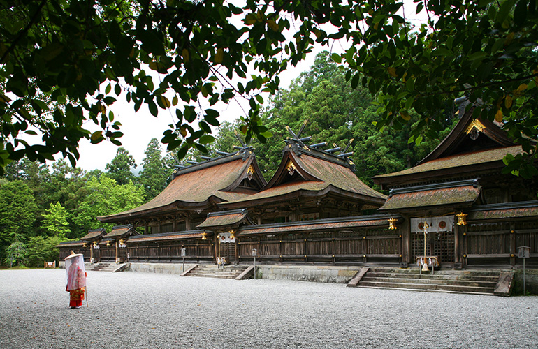
Kumano Hongu Taisha
Distance from Tsugizakura-oji: 21.5 kilometers
Total elevation gain: 960 meters
Total elevation loss: 1440 meters
After making your way through several passes that take you across bridges, rivers, mountain roads, and through woodland shrines, tea plantations, and yuzu orchards, you’ll come to the outskirts of Hongu. Your goal is the grand Kumano Hongu Taisha. In the area, you will find the towering Oyunohara torii gate, the largest in all of Japan.
The town of Hongu itself is where you will find several restaurants, shops, and guesthouses. Just two kilometers southwest, you will discover a steamy little village that many travelers on the Nakahechi trail come to enjoy: Yunomine Onsen.
Yunomine Onsen
Distance from Kumano Hongu Taisha: 2 kilometers
Total elevation gain: 250 meters
Total elevation loss: 190 meters
The tiny onsen village of Yunomine Onsen is a true gem over 1,800 years old. This makes it one of the oldest known hot springs in Japan. Serving as a rest stop between the Kumano Sanzan shrines, pilgrims of the past would come here to soak in the healing waters after a hard day of crossing the mountains. Today, modern pilgrims enjoy the novelty of spending time in a traditional Japanese ryokan and experiencing the rituals that come with an overnight stay. In the mornings, you will likely catch some locals boiling eggs and sweet potatoes in the hot spring water!
Kumano Hayatama Taisha
After paying tribute at Kumano Hongu Taisha, pilgrims would travel by traditional flat-bottomed boat down the sacred Kumano-gawa river to Kumano Hayatama Taisha. This is the second of the Kumano Sanzen shrines. Modern pilgrims may choose to take a bus to the town of Shingu where Kumano Hayatama Taisha resides, while others prefer to go straight to Kumano Nachi Taisha through Koguchi. At the shrine of Kumano Hayatama Taisha, you will find an impressive 800-year-old pine tree.
Kumano Nachi Taisha via Shingu
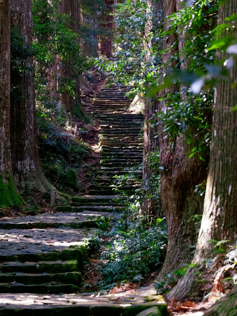
The third of the Kumano Sanzen shrines can be reached by traveling from Shingu to Nachi — just a short 20-minute train or bus ride away. From there, climb the magical 600-meter Daimon-zaka cobblestone staircase that runs from the base of the Nachi valley to the famous shrine and its incredibly scenic waterfall. Along the way, you will encounter ancient cedar trees, camphor trees, and bamboo groves. The Kumano Nachi Taisha marks the end of the Nakahechi trail.
Resources
Official area maps
The Tanabe City Kumano Tourism Bureau provides detailed hiking maps that include elevation and distance charts for the four main Kumano Kodo trails. Click here to view them.
Is Japan on your travel bucket list? Check out our two-minute guide “Why travel to Japan?” to discover the country’s best highlights!
About TourHero
TourHero is a social travel platform that enables you to travel with like-minded people and fall in love with the journey. We work closely with handpicked local operators to ensure every experience curated is unique and exclusive to your travel group. Come with us on epic adventures and create memories that last a lifetime. Get started here!